AI绘画地理教程:地图地形和地理景观的信息图设计
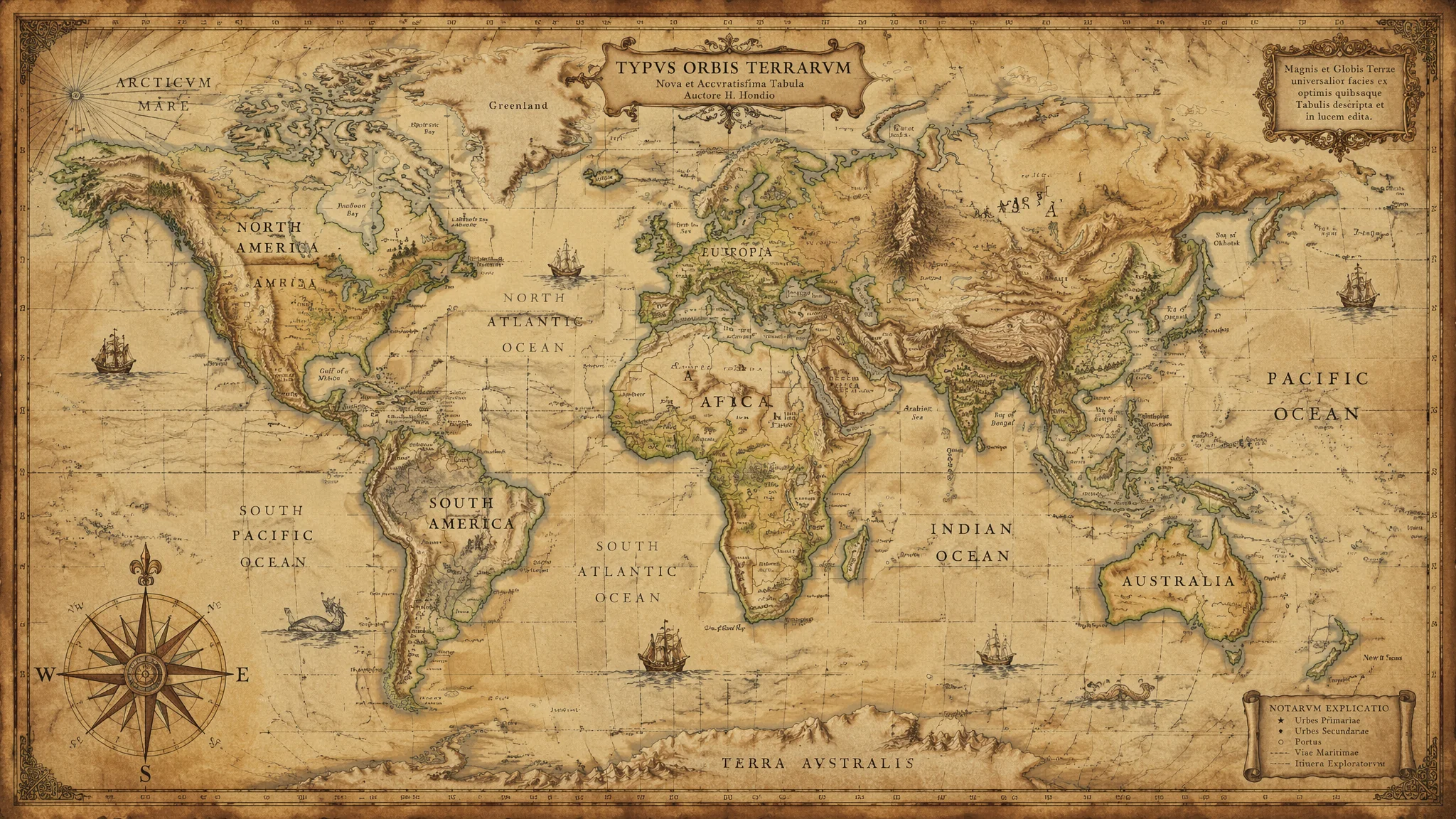
简单说:AI绘画地理地图核心是复古手绘+3D地形浮雕+城市鸟瞰+信息图数据可视化+奇幻世界地图+地质剖面+气候变化——复古手绘地图antique world map+parchment texture+hand-drawn cartography style+compass rose+sea monsters illustrations+ornate borders+sepia tones+16th century map style+copperplate engraving effect+latitude and longitude grid lines+rhumb lines+calligraphy place names。3D地形浮雕3D topographic relief map+layered contour lines+raised mountain ridges+deep valley shadows+satellite terrain data style+elevation color gradient from green lowlands to brown highlands to white snow peaks。城市鸟瞰detailed city map from above+grid street pattern+river winding through downtown+green parks as urban lungs+medieval European city organic street layout对比modern American city perfect grid blocks+isometric view 45 degree angle。地理信息图infographic world map+data visualization+color-coded regions+bar charts integrated into continents+气候地图global climate zones map+人口密度population density visualization+交通路线global shipping routes。奇幻世界地图fantasy world map+fictional continent+dragon-shaped landmass+elven forest regions+dwarven mountain strongholds+wizard tower location markers+volcanic archipelago+frozen northern wastes+vast desert with ancient ruins。地质剖面cross-section diagram of Earth's crust+layered rock strata+fossil deposits+underground water table+volcanic magma chamber+矿产分布mineral resource map+海洋地形ocean floor bathymetric map。气候变化glacier retreat over decades+deforestation map+global coral reef map+carbon emissions world map。地理地图参考可以看 Pinterest 的 map art 分类,大都会博物馆 的 map collection 也有大量经典。
当AI遇见地理:地图的艺术化表达
地图是最古老的信息图形式,将三维地球压缩到二维平面上,本身就是一种视觉艺术。AI绘画为地理表达带来了全新可能——复古羊皮卷手绘地图、现代3D地形浮雕、卫星视角城市肌理、科幻风格的星球表面。FlowPix在图形化内容和结构化的视觉元素方面表现优异,特别适合生成具有设计感的地理信息图。无论是教育用的地形示意图,还是装饰性的复古世界地图,AI都能将地理数据转化为令人着迷的视觉作品。
复古手绘风格地图
复古地图是AI地理绘画中最受欢迎题材——antique world map+parchment texture+hand-drawn cartography style+compass rose+sea monsters illustrations+ornate borders+sepia tones。装饰元素至关重要elaborate compass rose in corner+mythical sea creatures in oceans+sailing ships+decorative cartouche with title。陆地轮廓aged paper coastline+ink-drawn mountains+tiny tree symbols for forests产生手绘感。FlowPix能模仿文艺复兴时期地图师笔触加入16th century map style+copperplate engraving effect+yellowed aged edges进一步强化历史质感+细节latitude and longitude grid lines+rhumb lines radiating from compass roses+calligraphy place names。
复古地图是AI地理绘画中最受欢迎的题材。核心提示词"antique world map, parchment texture, hand-drawn cartography style, compass rose, sea monsters illustrations, ornate borders, sepia tones"。地图上的装饰元素至关重要——"elaborate compass rose in corner, mythical sea creatures in oceans, sailing ships, decorative cartouche with title"。陆地轮廓用"aged paper coastline, ink-drawn mountains, tiny tree symbols for forests"产生手绘感。FlowPix能够模仿文艺复兴时期地图师的笔触,加入"16th century map style, copperplate engraving effect, yellowed aged edges"进一步强化历史质感。细节丰富的地图可以添加"latitude and longitude grid lines, rhumb lines radiating from compass roses, calligraphy place names"。
3D地形浮雕与高度图
地形可视化是地理AI另一重要方向——3D topographic relief map+layered contour lines+raised mountain ridges+deep valley shadows+satellite terrain data style。色彩编码elevation color gradient from green lowlands to brown highlands to white snow peaks。FlowPix支持指定具体地形特征mountain range with sharp ridges+river valleys cutting through terrain+coastal shelf dropping to deep ocean生成的地貌形态准确而美观+地球局部俯视图top-down view of Himalayan range+realistic snow-capped peaks+deep gorges between mountains适合制作地理教学材料。
地形可视化是地理AI的另一重要方向。生成地形浮雕的关键提示词"3D topographic relief map, layered contour lines, raised mountain ridges, deep valley shadows, satellite terrain data style"。色彩编码很有讲究——"elevation color gradient from green lowlands to brown highlands to white snow peaks"。FlowPix支持指定具体地形特征,"mountain range with sharp ridges, river valleys cutting through terrain, coastal shelf dropping to deep ocean"生成的地貌形态准确而美观。地球局部的俯视图"top-down view of Himalayan range, realistic snow-capped peaks, deep gorges between mountains"适合制作地理教学材料。
城市鸟瞰图与街道路网
城市地理图展示人工与自然的交织——detailed city map from above+grid street pattern+river winding through downtown+green parks as urban lungs+miniature buildings。不同城市规划风格差异明显medieval European city+organic street layout+central cathedral square+city walls对比modern American city+perfect grid blocks+central business district skyscrapers+suburban sprawl。加入isometric view+45 degree angle+building shadows casting to right可以生成类似策略游戏地图的等距视角城市信息密度和美观度兼备。
城市地理图展示人工与自然的交织。提示词"detailed city map from above, grid street pattern, river winding through downtown, green parks as urban lungs, miniature buildings"。不同城市规划风格差异明显——"medieval European city, organic street layout, central cathedral square, city walls"对比"modern American city, perfect grid blocks, central business district skyscrapers, suburban sprawl"。FlowPix能区分这些空间模式并生成对应纹理。加入"isometric view, 45 degree angle, building shadows casting to right"可以生成类似策略游戏地图的等距视角城市,信息密度和美观度兼备。
地理信息图与数据可视化
风格化信息图是地理AI的实用方向——infographic world map+data visualization+color-coded regions+bar charts integrated into continents+clean modern design。气候地图global climate zones map+temperature gradient from tropical red to polar blue+weather symbols overlay。人口密度图population density visualization+bright dots clustering in urban areas+fading to dark in rural regions。交通路线图global shipping routes+dotted lines crossing oceans+major ports highlighted+minimalist design。
风格化信息图是地理AI的实用方向。提示词融合地图与图表语言——"infographic world map, data visualization, color-coded regions, bar charts integrated into continents, clean modern design"。气候地图"global climate zones map, temperature gradient from tropical red to polar blue, weather symbols overlay"。人口密度图"population density visualization, bright dots clustering in urban areas, fading to dark in rural regions"。交通路线图"global shipping routes, dotted lines crossing oceans, major ports highlighted, minimalist design"。FlowPix配合标注文字使用能生成半成品信息图,后续用设计软件添加文字即可用于演示和报告。
奇幻世界地图创作
虚构世界的地图是地理AI最具创意性的应用——fantasy world map+fictional continent+dragon-shaped landmass+elven forest regions+dwarven mountain strongholds+wizard tower location markers。用地理逻辑构建虚构volcanic archipelago+frozen northern wastes+vast desert with ancient ruins+enchanted islands in misty sea。old parchment fantasy map+glowing runes marking magical locations+dotted travel routes between cities这类描述生成的画面既有地图的功能感又有奇幻的艺术性+特别受游戏开发者和奇幻小说创作者欢迎。
虚构世界的地图是地理AI最具创意性的应用。提示词"fantasy world map, fictional continent, dragon-shaped landmass, elven forest regions, dwarven mountain strongholds, wizard tower location markers"。用地理逻辑构建虚构——"volcanic archipelago, frozen northern wastes, vast desert with ancient ruins, enchanted islands in misty sea"。FlowPix对于"old parchment fantasy map, glowing runes marking magical locations, dotted travel routes between cities"这类描述生成的画面既有地图的功能感又有奇幻的艺术性。这类作品特别受游戏开发者和奇幻小说创作者的欢迎。
地质剖面与自然资源图
地理AI还能表现地表之下的结构——地质剖面cross-section diagram of Earth's crust+layered rock strata+fossil deposits visible+underground water table+volcanic magma chamber below。矿产分布图mineral resource map+gold veins shown in yellow+coal seams in black+oil pockets underground。海洋地形ocean floor bathymetric map+deep trenches in dark blue+continental shelf in light blue+underwater mountain ranges。土壤类型分布soil distribution map+different colors for clay sand loam regions+agricultural regions marked。这些科学主题信息图对教育领域价值很高。
地理AI还能表现地表之下的结构。地质剖面"cross-section diagram of Earth's crust, layered rock strata, fossil deposits visible, underground water table, volcanic magma chamber below"。矿产分布图"mineral resource map, gold veins shown in yellow, coal seams in black, oil pockets underground"。海洋地形"ocean floor bathymetric map, deep trenches in dark blue, continental shelf in light blue, underwater mountain ranges"。土壤类型分布"soil distribution map, different colors for clay, sand, loam regions, agricultural regions marked"。这些科学主题的信息图对教育领域价值很高,FlowPix的图层式渲染让复杂的地质信息变得直观易懂。
气候变化与生态环境图
环境主题的地理信息图社会关注度高——冰川消退图before and after comparison+glacier retreat over decades+blue ice shrinking to brown rock+global warming visualization。森林覆盖变迁deforestation map+green forest areas turning to brown earth+satellite view comparison。珊瑚礁分布global coral reef map+vibrant underwater ecosystems marked in bright colors+bleached white areas showing decline。碳足迹地图carbon emissions world map+dense pollution clouds over industrial regions+clean air over oceans。FlowPix配合清晰色彩编码可生成具有传播力和教育意义的环境地理可视化作品。
环境主题的地理信息图社会关注度高。冰川消退图"before and after comparison, glacier retreat over decades, blue ice shrinking to brown rock, global warming visualization"。森林覆盖变迁"deforestation map, green forest areas turning to brown earth, satellite view comparison"。珊瑚礁分布"global coral reef map, vibrant underwater ecosystems marked in bright colors, bleached white areas showing decline"。碳足迹地图"carbon emissions world map, dense pollution clouds over industrial regions, clean air over oceans"。FlowPix配合清晰的色彩编码可生成具有传播力和教育意义的环境地理可视化作品。
AI画地图如何保持地形准确性?
如果追求真实地理,提示词中明确地理位置名称如"topographic map of Iceland, accurate coastline, real mountain locations"。FlowPix训练数据包含大量真实地理影像,指定地名可激活对应地理知识。如需准确度高的地图,后续可用专业GIS工具矫正。
能否生成特定历史时期的地图?
加入历史时期描述。罗马帝国地图"map of Roman Empire at its height, Mare Nostrum, Latin place names, Roman road network"。大航海时代"Age of Discovery world map, unknown southern continent, galleon ship routes, Terra Incognita labels"。
地图比例尺和指北针怎么加上去?
提示词加入"map legend in corner, scale bar at bottom, north arrow compass, title cartouche"。FlowPix会生成装饰性比例尺和指北针图案,如需精确设计元素,建议AI生成底图后在Photoshop或Illustrator中添加精确标注。
从教室里的地理挂图到设计师桌面的信息图海报,AI赋予了地图创作全新的维度。每一幅地理AI作品都是数据与美感、科学与艺术的交汇,也是探索世界的一种全新方式。
相关教程:AI绘画诸神教程——为奇幻世界地图设计守护神祇。AI极光绘画教程——极地地区地图的极光氛围渲染。AI转化绘画教程——将真实卫星图转化为不同地图风格。
分享与交流
你使用FlowPix创作过哪些地理主题的AI作品?复古手绘地图、3D地形图还是自己的奇幻世界?欢迎在评论区展示你的地图作品和提示词技巧。发布时添加 #FlowPix地理AI 标签,让更多地图爱好者看到你的创意。地理与AI的交汇,既有科学的精确又有艺术的自由。把世界装进一幅AI地图里,你收获的不仅是点赞,还有重新认识这颗星球的崭新视角。从孩童时期墙上那张世界地图,到今天你亲手用AI描绘的山川湖海,探索地理的冲动始终是人类最本真的好奇心之一。